|
|
dbS Productions |
|
|
Home Research Publications
Training Consulting|
Contact Us
|
Order Form |Events
|
||
| ||||||
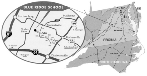
Directions: The Blue Ridge School is located one mile northwest of Dyke, Virginia, in the foothills of the Blue Ridge Mountains. The School is 30 minutes from downtown Charlottesville and about two hours from both Washington, D.C. and Richmond, Virginia.
From
Charlottesville and points east Take U.S. Route 29 North about 8 miles. Turn left onto Airport Road (State Route 649). Go to the traffic circle and bare left onto Dickerson Road (SR 606). Take Dickerson to the second traffic circle and bear right onto Earlysville Road (SR 743). Continue on Earlysville Road to Earlysville. At the general store in Earlysville, bear left onto Buck Mountain Road (SR 663, which becomes 664), and continue for 2 miles. Turn right onto Markwood Road (the continuation of SR 664). Stay on Markwood for 5 1/2 miles until it ends at the stop sign at the intersection of Markwood Road and Simmons Gap Road (SR 664, 663, and 810). At the intersection, go straight ahead on SR 810 for 1 1/2 miles to Dyke. At Snow's General Store in Dyke, turn left onto SR 627 and travel 1 mile to the stone-gated entrance to the School on the left. From Harrisonburg and points west Take U.S. Route 33 East approximately 40 miles. Turn right onto SR 810 and travel 7 miles to Dyke. In Dyke, turn right onto SR 627 at Snow's General Store. The stone entrance to the School is 1 mile on the left. From Richmond and point south Take Interstate 64 West to U.S. 250 Exit (Exit #124) to Charlottesville/Shadwell. Turn right onto U.S. 250 West, then merge onto U.S. 250 West Bypass. Turn right onto Hydraulic Road North (State Route 743). Turn right onto U.S. 29 North and take U.S. Route 29 North about 8 miles. Turn left onto Airport Road (State Route 649). Go to the stop sign and take a left onto Dickerson Road (SR 606). Take Dickerson to the stop sign and turn right onto Earlysville Road (SR 743). Continue on Earlysville Road to Earlysville. At the general store in Earlysville, bear left onto Buck Mountain Road (SR 663, which becomes 664), and continue for 2 miles. Turn right onto Markwood Road (the continuation of SR 664). Stay on Markwood for 5 1/2 miles until it ends at the stop sign at the intersection of Markwood Road and Simmons Gap Road (SR 664, 663, and 810). At the intersection, go straight ahead on SR 810 for 1 1/2 miles to Dyke. At Snow's General Store in Dyke, turn left onto SR 627 and travel 1 mile to the stone entrance to the School on the left. From Washington, D.C. and points north Take U.S. Route 29 South to Ruckersville. Turn right on U.S. Route 33 Bypass (West) and travel 7 miles to State Route 810. Turn left onto SR 810 and travel 7 miles to Dyke. In Dyke, turn right onto SR 627 at Snow's General Store. The stone entrance to the School is 1 mile on the left. Nearest Airports:
Charlottesville/Albermarle (CHO) (15 miles) | |||||||||||||||||||||||||||||
|
Home | SAR Research |Bookstore | Training Publications | Training Courses | Expert Witness | Consulting | About dbS | Order Form | Contact Us | Catalog Request |SAR Stories | What's New | Press Releases | Next Class | Find SAR Teams | SAR Links | SARsim 2001 | Urban Search | Copyright © 2000-2014 by dbS Productions |