|
The Four Corners of the Map
A statistical study on the phenomenon of how
searches occur at the corner of a topographic map
| Introduction | Methodology
| Results | Discussion | Acknowledgements
|
Introduction
One of the rules of search management is: Searches always occur
at the corner of a topographic map. Does in fact some mad sadistic search
god or goddess (please note little g) love to make the lives of incident staff
more miserable (we already know lost people only become lost after searchers
have settled into nice warm beds). With that thought in mind, and far too much
free time while preparing for NASAR's RESPONSE 97 the following study was
undertaken. It is hypothesized that the area found in the center of a
United States Geological Survey 7.5 minute topographical map is in fact rather
small. Therefore, it should not be too surprising that additional
topographical maps may be required in order to make a field map of 8.5 x 11
inches.
Methodology
A 7.5 minute USGS
topographical map of Portland Oregon was purchased from REI. Using the UTM
grid system already found on the borders, the map was grided into square
kilometer squares. More recent editions of USGS 7.5 minute maps now include the
UTM grid already overlaid with thin black lines. However, on this
particular map it was required to draw on the lines manually. A small dot
was then made in the center of each kilometer square. Only those squares
that consisted of an entire square kilometer were included. A small hole
was made in the center of an 8.5 x 11" sheet of paper. This size
paper was chosen since it represents the most common size of maps copied and
issued to field resources. The small hole on the 8.5x11" paper was
aligned with the each dot made on the grided USGS topographical map landscape
orientation. A data entry was then made if the 8.5x11" paper fit completely
on the grided map (One map), would have required a second map to
fill the 8.5x11" space (two maps), or located in the corner of the grided map would have required four maps to make a field map (four maps). This
procedure was repeated for each dot made on the grided map. Results:
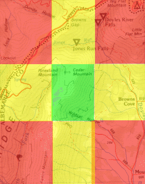
| Basic Pattern: Using the standard
sheet of paper (8.5x11") the following pattern became apparent.
Those searches that had a center point in the red areas (corners) would
require four topographical maps. Searches centered in the yellow
areas (middle sides) would require two maps. And those searches
centered (Initial Planning Point) in the green areas would only require
one map. The illustration (right) is not to scale.
The largest search radius that can fit on a standard sheet of paper is
4.25 inches (half of the shortest dimension). On a 7.5 minute
(1:24,000) map 4.25 inches represents 1.6 miles
Probability of maps required for standard sheet of paper.
| # of Maps |
% of Area |
| One Map |
25% |
| Two Maps |
40% |
| Four Maps |
35% |
|
 |
The above table gives the probability that mission staff will have to assemble
multiple maps if making a copy onto a standard sheet of paper
(8.5x11"). However, it does not give the probability that the entire
search area (typically the statistical max zone) will fit onto one
topographical map. Alzheimer's subjects with a max zone of 1.5 miles is
the only subject category that corresponds with a sheet of paper. The
second column, gives the probability of multiple maps for a three mile search
radius (hunters, lost children, mental retardation), the third column gives the probability of
multiple maps for a four mile search radius (lost hikers), while the last column
shows that all searches with a radius of 5 miles or greater (despondents,
psychotics) will require the four maps.
| # of Maps |
3 mile radius (% of
Area) |
4 mile radius (% of Area |
5 mile radius(% of Area) |
| One Map |
0% |
0% |
0% |
| Two Maps |
29% |
8% |
0% |
| Four Maps |
71% |
92% |
100% |
Discussion
In order to make a field map copied onto a standard sheet of copier paper
(8.5x11") a 75 percent possibility exists that maps must be taped together.
It is almost just as likely that it will require taping four maps as two maps together
in this scenario. It is also important to note that only searches
for Alzheimer's subjects will contain the entire search area (max zone = 1.5
miles) on a sheet of letter sized paper. All other subject search types
will require taping together at least two maps. Most of these other
searches will require taping four maps together. Using 15 minute maps will
also result in the same percentage of taping maps together. The percentage
of single, two, or four maps is based upon a ratio of scale. While the 15
minute map contains 4 times more information, the letter sized copied map also
contains 4 times more information. The above information was determined using a
map of Portland, Oregon. Topographical maps south of Portland while still 7.5
minutes will have more miles represented on the East-West line. This will
result in slightly greater chances of having the search fit on one map.
However, it should still be clear that a search that requires only one map is a
rare search. After all, there are four corners and only one middle to the
map! Acknowledgements:
It was a fine brand of Portland's Micro-brew
that helped foster the idea for this study. | Alzheimer's
| Retardation | Psychotic
| Despondent | VASARCO
| Fatigue | Map
| Latest | |